Canvas X Geo
20.0.1009
Powerful geospatial data illustration software. Make your geospatial data tell a story. Put actionable insights into the hands of key stakeholders, increasing productivity and enabling better informed decision making.
Size
300.2 MBVersion
20.0.1009
300.2 MBVersion
20.0.1009
Report this app
Description
Canvas X Geo Overview
Powerful geospatial data illustration software. Make your geospatial data tell a story. Put actionable insights into the hands of key stakeholders, increasing productivity and enabling better informed decision making.
Features of Canvas X Geo
- Real world accuracy
Position objects according to their latitude and longitude coordinates. Display the length and forward azimuth when measuring between two points, as well as the percentage of error. Measure distance in real world coordinates by drawing and selecting a line between two points. - Granular graticules
Create grids displaying the meridians of longitude and parallels of latitude. Precisely control units of measure, exact decimal levels, longitude and latitude start and edit points and spacing/divisions, latitude degree rotation, horizontal and vertical offsets, and even the label format settings. - Make your data pop
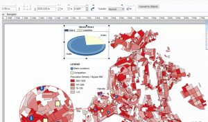
Take advantage of detailed fill, stroke, ink, and custom augmentation options for your GIS data visualization. Vary the appearance of map objects according to a selected property or a query to create thematic and choropleth maps. - Unmatched versatility
Canvas X Geo can import and access data in over 70 file formats.
System Requirements for Canvas X Geo
RAM: 8 GB
Processor: Intel® i3 or better 64-bit processor
Operating System: Windows 7, 8, 8.1, 10 and 11
Space Required: 4 GB
What's new
- Official site does not provide any info about changes in this version
Images